Latest Listings
Related Listings
Close To You


Meghri City
City
610 m
Historical
Medium
📍 Area: Approximately 77.7 km²
👥 Population: Around 4,159 (as of 2022)
🏘️ Administrative structure: Includes 15 settlements
🛣️ Distance from Yerevan: About 370 km
🚗 Getting there: Meghri is accessible from Yerevan via car or minibus, with an average travel time of 6–7 hours. The journey offers scenic views through the mountainous landscapes of Syunik. Given its location on the Armenian-Iranian border, Meghri hosts one of the country’s key border crossing points with the Islamic Republic of Iran, reinforcing its role as a vital hub for regional connectivity and trade.
OVERVIEW
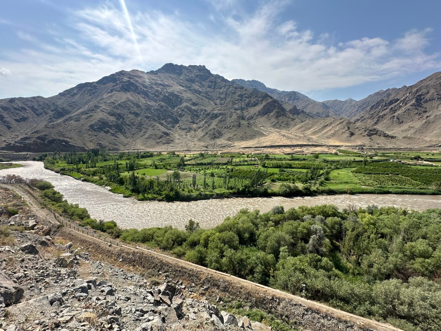
Meghri is Armenia’s southernmost border town, historically serving as a crossroads for trade, communication, and strategic transit. Nestled along the banks of the Araks River, Meghri has long connected Armenia to Persia and the broader southern region. Since ancient times, caravan routes have passed through this area, and during the medieval period, the town evolved into a key regional hub. Meghri’s historical layers reflect a deep and harmonious blend of Armenian culture with Persian influences, shaping a unique space where heritage lives in quiet urban simplicity.
ETYMOLOGY
The name “Meghri” is most commonly believed to derive from the Armenian word meghr (honey), meaning “honey,” reflecting the area’s long-standing tradition of beekeeping. Another theory traces the origin to the Persian word Mihr (sun), a reference to both the town’s sunny climate and its cultural proximity to Iran. Renowned Armenian geographer Kamsar Avetisyan proposed that the name may be linked to the sweet sap of the local fig trees, resembling honey in both taste and appearance. According to a popular legend, King Arshak II once tasted Meghri’s wine and exclaimed, “This is not wine, but honey!”-a phrase that, in folklore, is said to have inspired the town’s name.
HISTORY
Meghri, known as the southern gateway of Armenia, was founded in 906 AD during the reign of King Smbat I of the Bagratuni dynasty. In the medieval period, it was known as “Karchavan” and served as a strategic border settlement within the Bagratid Kingdom of Armenia. Positioned in the Araks River gorge, the town naturally evolved into a fortified outpost of regional importance. Between the 16th and 18th centuries, Meghri and its surrounding area came under Persian control multiple times. In the first half of the 19th century, it became part of the Russian Empire and was reorganized as a fortified border settlement with small castles and residences of local nobility. In 1930, Meghri became part of the Soviet Union as the administrative center of the “Meghri District,” and by 1959 it officially gained town status. Throughout the Soviet era, it developed into a hub for agriculture, industry, and border infrastructure. Meghri also played a role in the national liberation movements of Syunik in the early 18th century, with local residents actively participating under the leadership of Davit Bek and Sparapet Mkhitar. The town’s first parish school was founded in 1881, marking the beginning of formal education in the region.
ECONOMY
Meghri’s economy is driven by a combination of industry, agriculture, border trade, and service sectors—largely shaped by its distinctive semi-subtropical climate and location on the Armenian-Iranian border. The region is especially known for the cultivation of high-value fruits such as pomegranates, figs, and quinces. However, local processing and value-added production chains remain underdeveloped. The presence of the Agarak border crossing offers potential for the town to become a logistical hub, though that capacity is still underutilized due to infrastructural limitations. Future economic development strategies focus on enhancing food processing industries, boosting border-related services, and promoting tourism—goals that will depend on coordinated public policy and a favorable investment climate.
ARCHITECTURE
Meghri’s architectural landscape is defined by its flat-roofed houses, adorned with finely crafted wooden gates, doors, shutters, and railings-elements that reflect the traditional style typical of Syunik. The town’s historical layout is centered around two main districts: Poqr Tagh (Small District) and Mets Tagh (Large District), which together form the foundation of Meghri’s urban and communal identity.
Mets Tagh was historically the town’s administrative, religious, and commercial core, with densely built stone houses featuring deep courtyards and thick masonry walls. The architecture here showcases Syunik’s classic design: recessed balconies, stone staircases, and robust construction adapted to the climate and terrain. The district is also home to key heritage landmarks such as the 17th-century Surb Astvatsatsin (Holy Mother of God) Church and other former communal buildings.
In contrast, Poqr Tagh presents a more rural and tranquil setting, surrounded by fruit orchards and garden plots. Houses here are typically single-story, built from local clay stone, baked brick, and wood. The layout emphasizes open courtyards and functional household spaces, highlighting the agricultural lifestyle of the residents. The architecture of Poqr Tagh has a more modest, vernacular character-simple yet well adapted to family life and environmental conditions.
Although modern renovations over the past decades have partially altered the traditional appearance of these neighborhoods, many historical elements have been preserved. A number of homes still retain their arched or lattice-frame windows and wooden doors-testaments to 19th and early 20th century local craftsmanship. Inside, one can still find vintage fireplaces, wooden ceilings, and built-in wall niches, offering a tangible link to Meghri’s cultural past.
TOURISM
Meghri is a truly unique travel destination where centuries-old heritage blends harmoniously with the vibrant nature of Armenia’s southern frontier. Wandering through the city’s historic quarters, visitors can feel the breath of the medieval past-expressed in flat-roofed homes, finely carved wooden gates, and traditional lattice windows. The area is rich in historic landmarks, religious sites, and architectural details characteristic of the Syunik region. Meghri’s green valleys, surrounding hills, and spring-fed landscapes create an ideal setting for hiking, nature photography, and tranquil escapes.
Key tourist attractions in Meghri include:
- Meghri Fortress - A medieval hilltop stronghold offering panoramic views over the town.
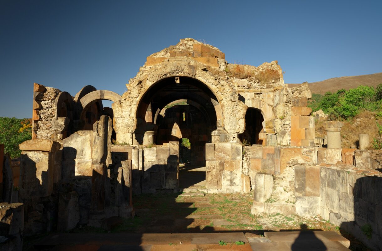
- Surb Astvatsatsin Church (1673) - Located in Mets Tagh, this 17th-century church is known for its rare and vibrant interior frescoes.
- Surb Hovhannes Church - A 17th-century church with traditional architecture, located in Poqr Tagh.
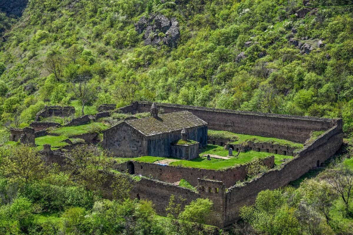
- Meghri Monastery (15th-18th centuries) - A historic religious complex perched on a hillside, featuring elements of medieval Armenian ecclesiastical architecture.
- Old Chinar Tree - A centuries-old tree in the center of town, long serving as a communal gathering place for local residents.
- Ancient Stone Bridges - Scattered throughout the region, these preserved bridges once served as key connections between remote settlements.
- Shvanidzor Bridge - A traditional stone bridge linking Meghri to the historic village of Shvanidzor.
- Historic Aqueduct - A 17th-century basalt aqueduct in Shvanidzor, constructed with lime mortar, once used to supply drinking and irrigation water.
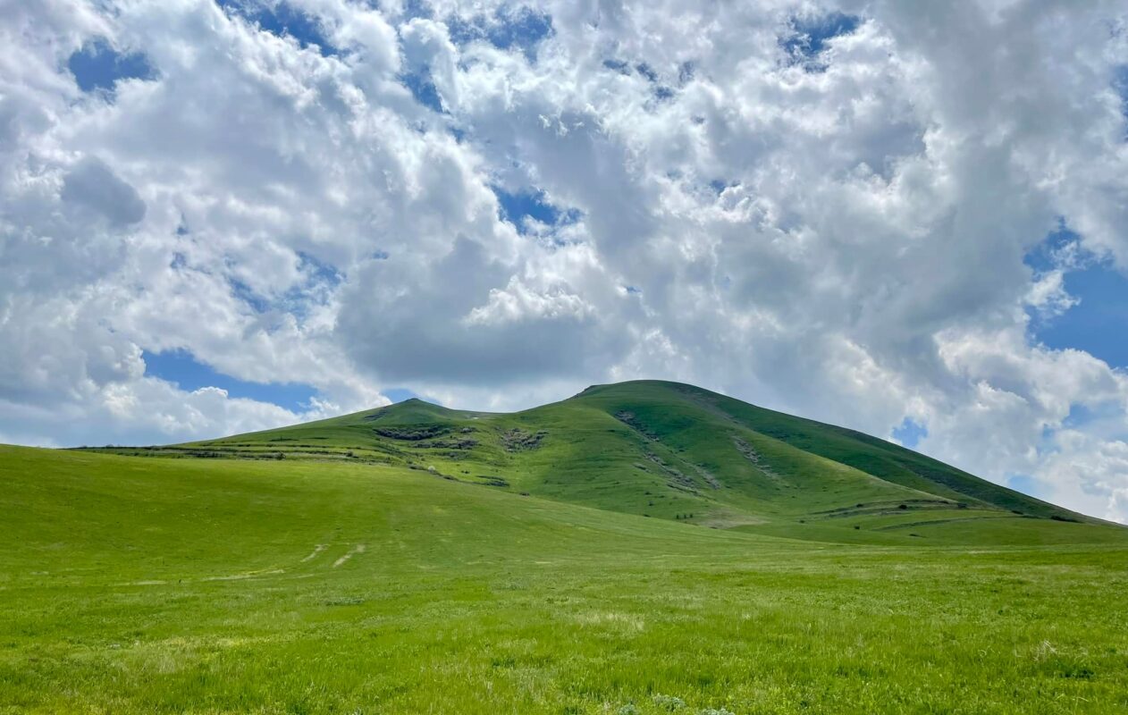
- Araks River Valley - The fertile lowlands surrounding Meghri, rich with orchards and river gorges-ideal for hiking and peaceful retreats in nature.
- Arevik National Park - A protected area with exceptional biodiversity, particularly known for its birdlife and endemic species.
- Lichk Waterfalls - A series of four scenic waterfalls along the Zvaraget and Meghri rivers, offering stunning trails for nature lovers and hikers.
- Poqr Tagh - One of Meghri’s oldest districts, showcasing preserved traditional homes with wooden balconies, deep courtyards, and decorative stonework.
Facilities
Nearby
Located in Meghri’s Pokr Tagh district, this 15-17 centuries Armenian Apostolic church is known for its 18-19 centuries frescoes inspired by Naghash Hovnatan’s school. The church became a major spiritual site in 2022 with the arrival of a relic – the right hand of St. John the Baptist.
Located in the center of Meghri, this 17th-century church is considered a masterpiece of Armenian ecclesiastical architecture. It is especially renowned for its exceptionally well-preserved frescoes depicting biblical scenes and saints. The church has remained largely unchanged and continues to serve as an important spiritual center for the local community.
One of the oldest neighborhoods of Meghri, Poqr Tagh is characterized by its narrow, winding streets, stone-built traditional houses, and authentic Armenian village architecture. A walk through this quarter provides visitors with a glimpse of historical Meghri and its preserved cultural atmosphere.
Situated in southern Syunik, Arevik is one of Armenia’s richest biodiversity reserves. It is home to many rare plant and animal species, including the endangered Caucasian leopard. The Park offers scenic hiking trails, pristine natural landscapes, flowing rivers, and waterfalls, making it a perfect destination for nature lovers.
Located northeast of Meghri, Shvanidzor is a remote and picturesque village known for its preserved Armenian rural architecture and traditional lifestyle. The village is also a gateway to the Old Bridge of Shvanidzor, a 17th-century stone bridge surrounded by lush vegetation, making it a unique destination for eco-tourism and cultural exploration.
Gallery
")
")
")
")
")
")
")
")
")
")
")
")
")
")

")
The ownership of these photos belongs to Lusine Nersesyan.