


")
")
")
")
")
")
Гора
2299 м
Природный
Средний
📍 Расположение - Котайкская область, в 2,53 -км к югу от села Фантан и примерно в 4 км к северо-востоку от села Джрабер.
🕰️ Геологический период - Плиоцен. Гора сформировалась в результате излияния древней лавы и вулканического шлака.
🌐 Координаты - 40.3343° N, 44.6625° E
🌿 Лучшее время для посещения - С апреля по октябрь, весной и осенью, когда природа окрашивается в яркие тона, а погода мягкая и комфортная.
🛤️ Как добраться - Из Еревана можно доехать через Абовян и Ехвард в направлении села Фантан (Котайкская область). От села до подножия горы ведет тропа длиной около 3 км, которую можно пройти пешком или на внедорожнике.
ОБЗОР
Гутанасар - потухший вулкан, расположенный в западной части Гегамского хребта. Гора отличается идеальной конусообразной формой и хорошо сохранившимся кратером. Ее высота достигает 2299 метров, а основная масса сложена из плиоценовых лав и вулканического шлака. На южном склоне видна трещина - древний канал, по которому текла лава. В окрестностях горы обнаружены залежи перлита и пемзы, подтверждающие ее вулканическое происхождение.
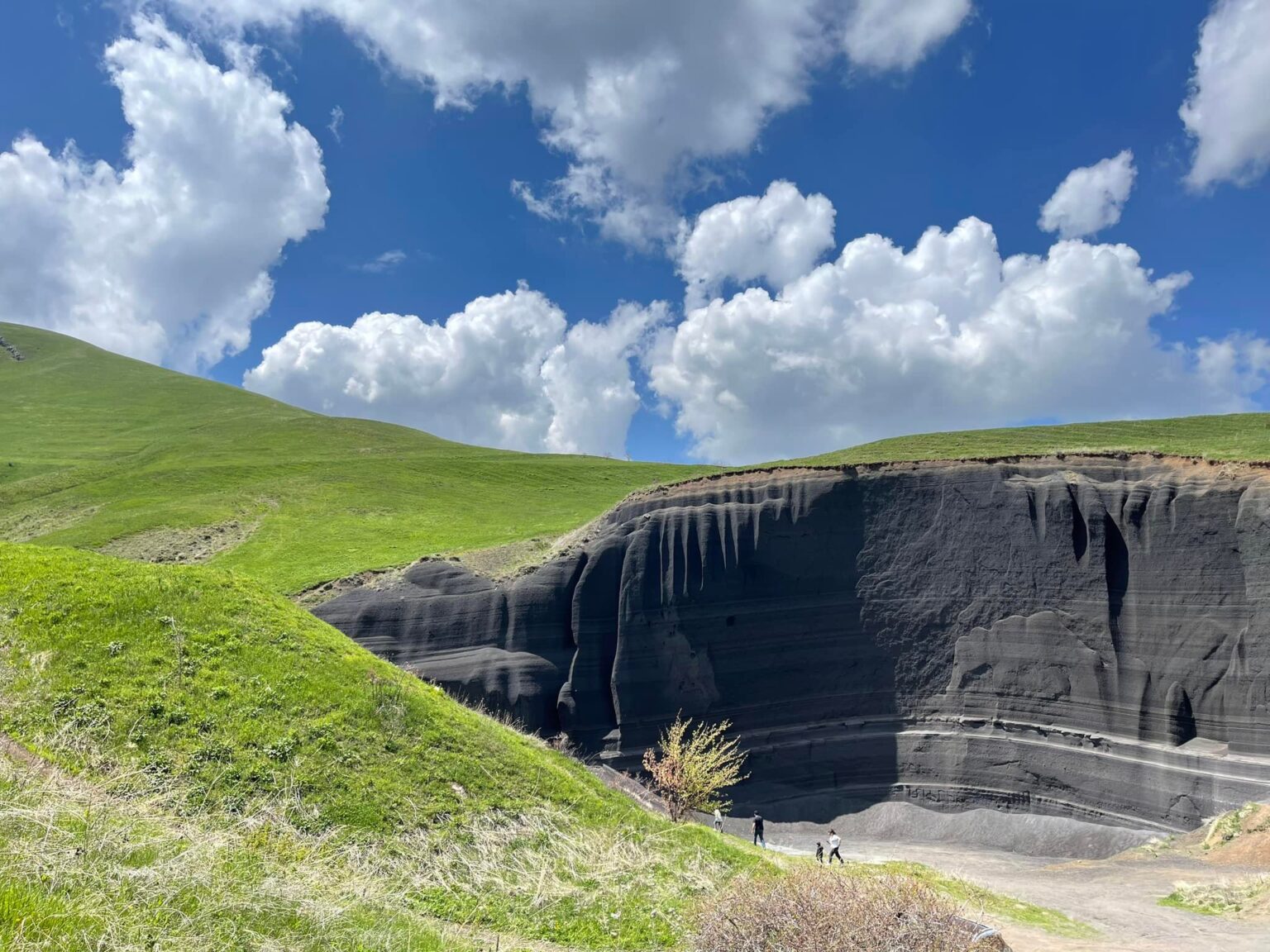
Недалеко от подножия горы расположена местность, известная как “Черные Пески” - необычный природный ландшафт, сформировавшийся за тысячи лет под воздействием ветра и осадков. Эрозия вулканических пород создала песчано-глинистые слои различных оттенков. В зависимости от угла падения солнечных лучей поверхность переливается от серебристо-серого до коричнево-красного цвета, создавая завораживающую игру красок. Это место стало настоящим открытием для фотографов и любителей дикой природы.
ЭТИМОЛОГИЯ
Согласно распространенному толкованию, название Гутанасар происходит от армянского слова «гутан» - «плуг». Если смотреть сверху, очертания вершины и склонов действительно напоминают форму плуга. По другой версии, название связано с земледелием, так как окрестности горы на протяжении веков использовались как пастбища и плодородные пашни.
ИСТОРИЯ
Гутанасар образовался примерно два-три миллиона лет назад. В советский период район изучался геологами как возможное место для добычи пемзы и перлита, однако промышленная разработка не велась, чтобы сохранить природную красоту местности.
На склонах горы четко видны следы эрозии: ветер, дождевые потоки и движение грунта в течение тысячелетий сформировали уникальные разноцветные пласты. Эти оттенки вызваны различным минеральным составом пород — присутствием железа, марганца и оксидов. В окрестностях были найдены древние каменные орудия и предметы быта, свидетельствующие о том, что территория была заселена еще в доисторические времена. Таким образом, Гутанасар представляет интерес не только как геологический, но и как археологический объект.
Сегодня гора является важным направлением эко- и геотуризма. Здесь часто проводятся полевые исследования, приезжают студенты и ученые, а также фотографы, которых привлекает необычная цветовая палитра и живописные контрасты ландшафта.
На южном склоне находится так называемая “Черная Стена” - открытый фрагмент вулканического ядра, демонстрирующий древний поток лавы и внутреннюю структуру пород. Этот естественный базальтовый обнаженный пласт, образовавшийся при застывании расплавленной лавы, считается одной из самых выразительных геологических особенностей Гутанасара.
ФЛОРА И ФАУНА
Окрестности Гутанасара характеризуются горно-степными и частично горно-луговыми ландшафтами. На нижних склонах растут сухостепные растения - дикие злаки, ромашка, маки и тимьян. На более высоких уровнях встречаются луговые травы и лекарственные растения: ковыль, душица, зверобой, вечерница. Весной и в начале лета склоны покрываются множеством разноцветных цветов, создавая живописный пейзаж.
Животный мир представлен типичными для горно-степной зоны видами: здесь обитают зайцы, лисицы, ежи, а также птицы - голуби, соколы, горные воробьи. Иногда встречаются следы леопарда и дикой кошки. Местность также богата бабочками и насекомыми, особенно заметными весной, когда природа наиболее активна.
ТУРИЗМ
В последние годы Гутанасар и его песчаные окрестности стали популярным направлением для любителей природы, эко- и пешего туризма. Местность подходит для коротких и средних походов, фотоэкспедиций и наблюдений за природой.
Хотя прогулка на Гутанасар может занять целый день, маршрут можно совместить с посещением монастыря Негуц, монастыря Тегеняц или церкви Святого Фаддея в Арзакане, создав путешествие, объединяющее природу, культуру и живописные горные пейзажи Армении.
МЕСТНЫЕ ЛЕГЕНДЫ
О Гутанасаре не сохранилось широко известных письменных легенд, однако в окрестных селах Котайкской области до сих пор рассказывают устные предания, связывающие гору с древними временами и загадочными природными явлениями.
По одной из легенд, источники, вытекающие со склонов горы, обладают целебной силой. Местные жители верят, что гора живая, и после каждой грозы в ее недрах открывается новый родник. Считалось, что вода из этих источников укрепляет тело и защищает от болезней, поэтому в течение поколений люди пили только «воду Гутанасара».
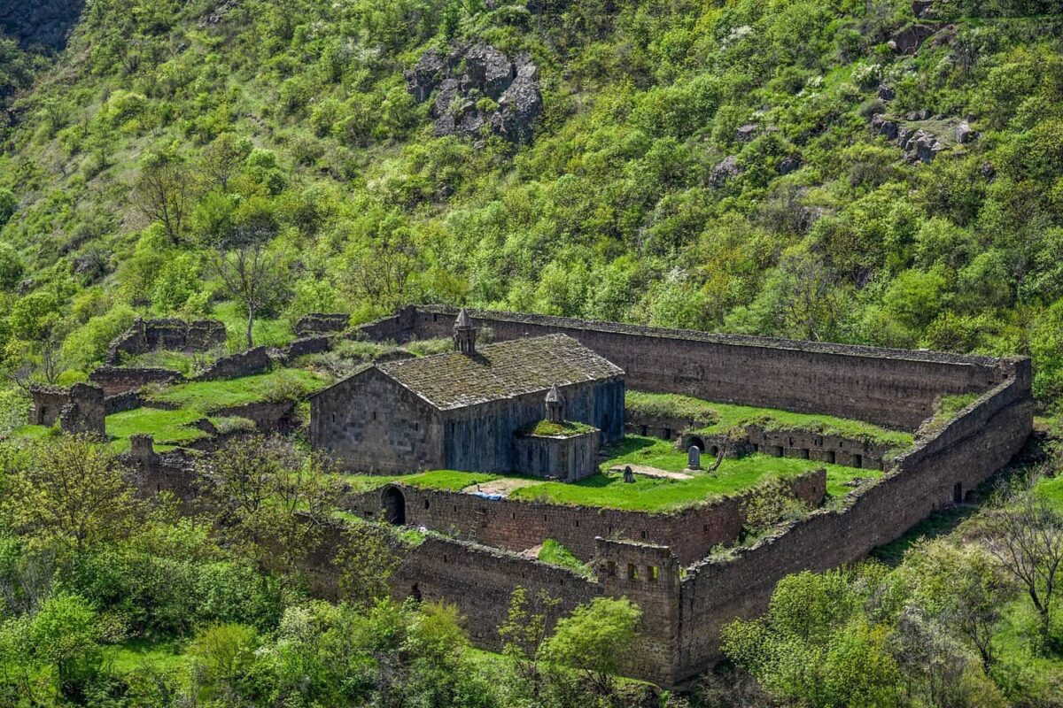
Средневековый монастырский комплекс в Котайкской области, недалеко от села Негуц. Построен из базальта и окружен густыми лесами. Известен своей сдержанной, но гармоничной архитектурой и умиротворенной атмосферой.
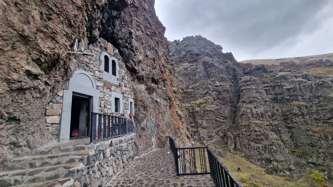
Древний монастырь на склонах горы Тегенис, среди лесов и источников. Основан в Средние века, служил духовным и образовательным центром. Каменная кладка и расположение сооружений прекрасно сочетаются с природным окружением.
Ранняя средневековая церковь в селе Аргели, построенная из местного туфа. Однонефное здание отличается простотой и выразительностью форм, сохранившихся до наших дней.
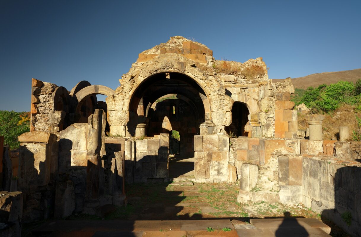
Построен в XIII веке. Представляет собой крестово-купольную церковь из серого туфа, окруженную лесистыми склонами. Вокруг сохранились хачкары и остатки древних построек, что указывает на значимость комплекса как духовного и общественного центра Средневековья.
Природные минеральные источники с температурой воды +32-36°C, богатой полезными микроэлементами. Расположены недалеко от села Арзкан и известны своими целебными свойствами и спокойной природной атмосферой. Это одно из лучших мест для отдыха и восстановления сил в горах Армении.
✓ Продолжительность: Неограниченно
✓ Основная контактная информация:
✓ Ограниченные фильтры
✓ Уведомления о новостях
✓ Продолжительность: 6 месяцев
✓ Включает подробную информацию:
✓ Уведомления о новостях
✓ Расширенные фильтры
AMD 40,000
✓ Продолжительность: 12 месяцев
✓ Включает подробную информацию:
✓ Уведомления о новостях
✓ Расширенные фильтры
✓ Скидка 20% на первый год
AMD 75,000
Уведомление об ответственности для Армянского туристического справочника
"Армянский туристический справочник" предоставляет платформу для бизнеса, связанного с туризмом, включая отели, туристические агентства и гидов, для размещения своих услуг. Информация на этом сайте предоставляется сторонними рекламодателями, и Армянский туристический справочник не несет ответственности за качество услуг или содержание, представленное на сайте.
Армянский туристический справочник не несет ответственности за любые прямые, косвенные, случайные или последующие убытки, возникающие в результате использования или невозможности использования услуг и контента на этом сайте. Компания не гарантирует доступность, качество, безопасность, законность или пригодность любого бизнеса или услуги, размещенной на сайте. Пользователи взаимодействуют с рекламодателями на свой страх и риск.
Рекламодатели несут полную ответственность за точность информации, которую они предоставляют, включая описания, изображения и другой контент, связанный с их бизнесом. Любые споры, претензии или юридические вопросы, связанные с услугами или бизнесами, представленными в Армянский туристический справочник, должны решаться непосредственно между пользователем и рекламодателем. Платформа не участвует в разрешении споров и не несет ответственности за их урегулирование.
Армянский туристический справочник может содержать ссылки на внешние сайты, которые не управляются и не контролируются компанией. Компания не несет ответственности за содержание, политику конфиденциальности или практику сторонних веб-сайтов.
Армянский туристический справочник оставляет за собой право изменять, обновлять или удалять контент с веб-сайта в любое время без предварительного уведомления. Рекламодателям рекомендуется регулярно проверять сайт для получения актуальной информации и обновлений․
Пользователи и рекламодатели обязаны соблюдать все применимые законы и нормативные акты при использовании сайта. Армянский туристический справочник не несет ответственности за любые нарушения, совершенные пользователями или рекламодателями, включая, но не ограничиваясь, мошенничество, предоставление ложной информации или нарушение юридических обязательств.
Все товарные знаки, логотипы, дизайнерские элементы и другие материалы на Армянский туристический справочник являются собственностью компании. Несанкционированное использование, воспроизведение или распространение этих материалов строго запрещено.
Используя сайт Армянский туристический справочник, пользователи и рекламодатели подтверждают, что понимают и соглашаются с данным уведомлением об ответственности.